


GPS NMEA Tool

GPS NMEA Tool açıklaması
GPS NMEA is a small tool to view NMEA data returned by the built-in gps receiver.
It has got three views that enables to view,
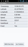
1. Summary of data which includes latitude, longitude, altitude, speed etc
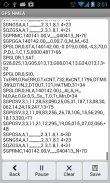
2. Shows the RAW NMEA data returned by the GPS
3. Allows to pause or save (to external media) a set of sample raw data for analysis
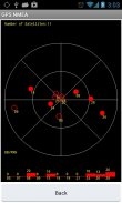
4. Show positions and the signal strength of the satellites in view
Notes: You have to enable location access for GPS to get the location data
Also when you saving data the external media may not be accessible if its has been
mounted by the user on their computer.
Please mail to the developer if anything not working or needs improvement
Thanks for visiting GPS NMEA app
</div> <div jsname="WJz9Hc" style="display:none">GPS NMEA dahili gps alıcısı tarafından döndürülen NMEA veri görüntülemek için küçük bir araçtır.
Bu görüntülemenizi sağlayan üç hit var
1. Enlem, boylam, yükseklik, hız vb içeren veri Özeti
2. GPS tarafından döndürülen RAW NMEA veri gösterir
3. Duraklatmak için izin verir veya (dış ortam için) analiz için örnek ham veri kümesi kaydetmek
4. Göster pozisyonları ve görünümünde uyduların sinyal gücü
Notlar: Bu konum verileri almak için GPS konum erişimi sağlamak zorunda
Onun olmuşsa da veri kaydederken harici ortam erişilebilir olmayabilir
kendi bilgisayarında kullanıcı tarafından monte.
Şey çalışan veya iyileştirme ihtiyacı değilse geliştirici mail lütfen
GPS NMEA uygulaması ziyaret ettiğiniz için teşekkür ederiz</div> <div class="show-more-end">
GPS NMEA Tool - Sürüm 1.1
(05-07-2014)
GPS NMEA Tool - APK Bilgisi
APK sürümü: 1.1Paket: com.ppillai.gpsnmeaGPS NMEA Tool uygulamasının en son sürümü


Aynı kategorideki uygulamalar
 4.284.463.784.073.37
Hoşuna gidebilecekler...


